Lifetime Goal: Each of the “Lower 48” States
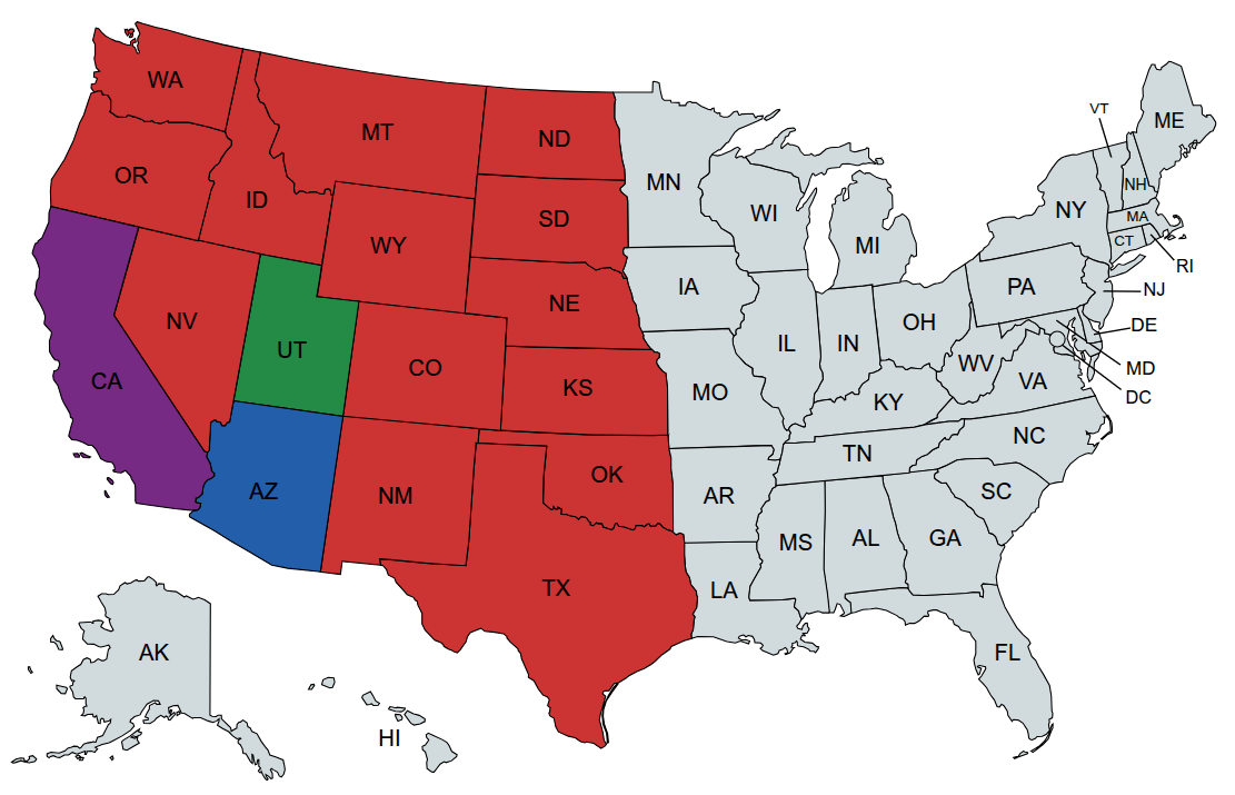
States: 17 … Percentage: 35.4%
Accomplishments:
| Map | State | Date | Location and Trip Report | Lat | Lon | Elev | Feels Like Max (F) | Feels Like Min (F) |
|---|---|---|---|---|---|---|---|---|
| Arizona | 2023-06 | Dairy Springs Campground, Flagstaff, Coconino National Forest | 34.95611 | -111.48689 | 7170' | 73.9 | 45.5 | |
| Arizona | Organ Pipe Cactus National Monument | |||||||
| Arizona | 2026-05 | Grand Canyon National Park | 36.04644 | -112.12004 | 6995' | 77 | 32 (this must be at the bottom of the Grand Canyon) | |
| Arizona | 2026-10 | Coronado National Forest - Rose Canyon | ||||||
| Arkansas | 2026-09 | Ouachita National Forest, Charlton Recreation Area | ||||||
| California | 2023-2026 | Various Counties in the State of California | ||||||
| Colorado | 2024-09 | Glenwood Springs, Garfield County | 39.56209 | -107.38036 | 5761' | 79.3 | 55.9 | |
| Colorado | 2027 | Glacier Basin Campground, Rocky Mountain National Park | ||||||
| Colorado | 2026-09 | Black Canyon of the Gunnison | ||||||
| Idaho | 2023-09 | Bell Bay Campground, Coeur d'Alene River Ranger District of the Idaho Panhandle National Forests | 47.47279 | -116.84234 | 2600' | 53.7 | 43 | |
| Idaho | 2027 | Lava Flow Campground, Craters of the Moon National Monument & Preserve | ||||||
| Illinois | Starved Rock State Park | |||||||
| Iowa | Maquoketa Caves State Park | |||||||
| Kansas | 2024-09 | Cheney State Park, Kingman County | 37.733292 | -97.836181 | 1450' | 81.3 | 66.5 | |
| Kentucky | 2026-10 | Koomer Ridge Campground - Daniel Boone National Forest | ||||||
| Michigan | Pictured Rocks National Lakeshore | |||||||
| Minnesota | Split Rock Lighthouse State Park Bike on the Paul Bunyan State Trail | |||||||
| Missouri | Berryman Campground, Mark Twain National Forest | |||||||
| Montana | 2025-08 | Glacier National Park | 48.54732 | -113.98444 | 3211' | 67 | 54.5 | |
| Nebraska | 2025-08 | Fort Robinson State Park | 42.67410 | -103.47820 | 3880' | 81.4 | 53 | |
| Nevada | 2024-09 | Atlatl Rock Campground-Valley of Fire, Clark County | 36.41756 | -114.55260 | 2263' | 99.7 | 80.3 | |
| Nevada | 2026-09 | Atlatl Rock | ||||||
| Nevada | 2027 | Upper Lehman Creek Campground - Great Basin National Park | ||||||
| Nevada | Thomas Canyon Campground - Ruby Mountains | |||||||
| New Mexico | 2024-09 | Cochiti Recreation Area, Sandoval County | 35.64468 | -106.33181 | 5584′ | 82.3 | 56.9 | |
| New Mexico | 2026-09 | Sugarite Canyon State Park | ||||||
| New Mexico | 2026-10 | Cloudcroft First-come-first-served | ||||||
| North Carolina | Cape Point Campground Cape Hatteras National Seashore | |||||||
| North Carolina | 2026-10 | Mt. Pisgah Campground | ||||||
| North Dakota | 2025-08 | Theodore Roosevelt National Park | 46.95047 | -103.53304 | 2247' | 87.1 | 55.8 | |
| Oklahoma | 2024-09 | Turner Falls Park, Arbuckle Mountains, Murray County | 34.42227 | -97.16391 | 988' | 84.3 | 51.7 | |
| Oregon | 2025-08 | Crater Lake National Park | 42.86780 | -122.16495 | 6020' | 81.8 | 56 | |
| South Dakota | 2025-08 | Black Hills National Forest | 43.87536 | -103.44091 | 4506' | 79.8 | 50.4 | |
| Tennessee | 2026-09 | Natchez Trace State Park | ||||||
| Texas | 2024-09 | Palo Duro Canyon State Park, Randall County | 34.96778 | -101.67070 | 2828' | 86.5 | 59.4 | |
| Utah | 2023-08 | Deer Creek State Park, Wasatch County | 40.41229 | -111.50371 | 5417' | 87.3 | 66.3 | |
| Utah | 2025-08 | Fishlake National Forest | 38.25706 | -112.54366 | 6469' | 83.8 | 60.9 | |
| Utah | 2025-05 | Bryce Canyon National Park | 37.63622 | -112.16647 | 7943′ | 42.3 | 28.5 | |
| Virginia | 2026-10 | Big Meadows Campground - Shenandoah National Park | ||||||
| Washington | 2025-08 | Mt. Rainier National Park | 46.99347 | -121.53257 | 2652' | 67.4 | 46.5 | |
| Wisconsin | Devil's Lake | |||||||
| Wyoming | 2025-08 | Grand Teton National Park | 44.10400 | -110.66605 | 6844' | 69.7 | 32.4 | |
| Wyoming | 2027 | Madison Campground, Yellowstone National Park |
Notes on How this Table is Filled-In:
- My phone embeds GPS data into my photos which provides the Latitude and Longitude.
- Knowing the Lat/Lon, I then go to https://whatismyelevation.com/ to determine my elevation. Satellite data from NASA and other public agencies is combined to create what is called a Digital Elevation Model which is a detailed list of elevation values for points on the Earth’s surface. Their tool then uses Lat/Lon to fetch the value elevation reading in the DEM.
- Knowing the Lat/Lon/Date, I then go to https://www.visualcrossing.com/ to determine the “Feels Like” Max/Min. Their weather engine processes billions of hourly and sub-hourly weather observations from more than one hundred thousand worldwide observation stations, including satellite and maritime sources to create our global weather observation database. The weather engine then aggregates and interpolates from these records to create the most accurate report.
- The “feels like” is the temperature equivalent perceived by humans, caused by the combined effects of air temperature, relative humidity and wind speed
Wish List:
- George S. Mickelson Trail
- Olympic Discovery Trail
- Katy Trail
- Rock Island Trail
- Palouse to Cascades State Park Trail
- Northern Rail Trail
- Erie Canalway Trail
- Ohio to Erie Trail
- Great Allegheny Passage
- Chesapeake & Ohio Canal Trail
- Shining Sea Bikeway (Massachusetts)
- Provo River Parkway (Utah)
- Monterey Bay Coastal Recreational Trail (California)
- Rincon Bike Trail (California)
- River Mountains Loop Trail (Nevada)
- Grand Teton Pathway (Wyoming)
- Shark Valley Trail (Florida)
- Paul Bunyan State Trail (Minnesota)
- Banks-Vernonia State Trail (Oregon)
- Great American Rail-Trail (13 States, Washington State to Washington, DC)
- The Silver Comet and Chief Ladiga Trails.
Site: 18, Loop: Upper Lehman
Part of Great Basin National Park | Near Baker, Nevada