Lifetime Goal: Each of the 58 counties in California
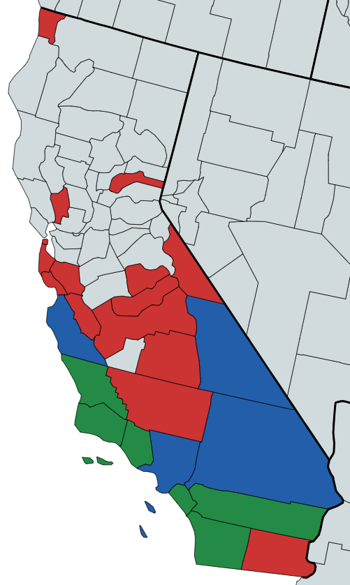
Counties: 25… Percentage: 43%
| Map | County | Date | Location and Trip Report | Lat | Lon | Elev | Feels Like Max (F) | Feels Like Min (F) |
|---|---|---|---|---|---|---|---|---|
| Alameda | ||||||||
| Alpine | ||||||||
| Amador | ||||||||
| Butte | ||||||||
| Calaveras | 2026-07 | Calaveras Big Trees SP | ||||||
| Colusa | ||||||||
| Contra Costa | ||||||||
| Del Norte | 2025-08 | Del Norte Coast Redwood National and State Park | 41.69750 | -124.09538 | 405' | 64 | 51.9 | |
| El Dorado | ||||||||
| Fresno | Sheeps Creek, Sentinel, Canyon View, Moraine.... Kings Canyon National Park | |||||||
| Fresno | 2024-05 | Dorabell Campground, Shaver Lake, Sierra National Forest | 37.11364 | -119.31151 | 5434' | 85.7 | 59 | |
| Glenn | ||||||||
| Humboldt | 2026-08 | Humboldt Redwoods State Park - Albee Creek Camp #25AC | ||||||
| Imperial | 2025-02 | Boondocking (which means nowhere in particular) | 33.38156 | -115.64485 | (-54)' | 79.8 | 52.3 | |
| Inyo | 2023-12 | Furnace Creek, Death Valley National Park | 36.46348 | -116.87006 | (-207)' | 58.2 | 38 | |
| Inyo | 2025-10 | Lone Pine Campground | 36.59750 | -118.18532 | 5873' | 47 | 27.6 | |
| Inyo | Grandview Campground - Bristlecone Pines | |||||||
| Kern | Tehachapi Mountain Park | |||||||
| Kern | Red Rock Canyon State Park | |||||||
| Kern | 2025-11 | Fort Tejon State Park | 34.87134 | -118.89744 | 3274' | 65 | 43 | |
| Kings | Boondocking | |||||||
| Lake | ||||||||
| Lassen | Goumaz Campground, next to the Susan River | |||||||
| Los Angeles | Castaic Lake SRA | |||||||
| Los Angeles | Catalina Island - https://catalinaconservancy.org/recreation/biking/ To ride in Catalina’s interior, all cyclists must have a Freewheeler Bike Pass, available with the purchase of a Catalina Island Conservancy membership, starting at just $50. | |||||||
| Los Angeles | 2024-10 | Crystal Lake Campground, San Gabriel Mountains National Monument | 34.32588 | -117.83712 | 5714' | 85.4 | 59.1 | |
| Los Angeles | 2026-01 | Leo Carrillo State Park | 34.05014 | -118.93465 | 31' | 63 | 53 | |
| Los Angeles | Malibu Creek State Park | |||||||
| Madera | 2024-04 | Codorniz Recreation Area | 37.21305 | -119.96810 | 664' | 79.3 | 52.8 | |
| Marin | Bicentennial Campground | |||||||
| Mariposa | 2024-06 | Wawona Campground, Yosemite National Park | 37.55087 | -119.68423 | 3920' | 80.9 | 59.3 | |
| Mendocino | MacKerricher State Park – near Ft. Bragg | |||||||
| Mendocino | 2026-07 | Hendy Woods State Park | ||||||
| Merced | 2026-06 | San Luis Reservoir State Recreational Area | ||||||
| Modoc | 2026-07 | Lassen Creek Campground From Alturas go north on US Hwy 395 approximately 20 miles to Davis Creek. Turn east on County Road 11 and continue approximately 9 miles to County Road 30/Modoc Backcountry Discovery Trail and turn left/north. Continue north approximately 15 miles to the campground on the right. Alternately, continue past Davis Creek to Co. Rd. 47, turn right (east) and follow the few signs to the campground. | ||||||
| Mono | Big Bend Campground | |||||||
| Mono | 2026-04 | Convict Lake | 37.59456 | -118.84933 | 7629' | 45 | 20 | |
| Monterey | Plaskett Creek Campground | |||||||
| Monterey | Limekiln Campground | |||||||
| Monterey | Kirk Creek Campground | |||||||
| Monterey | 2024-01 | Pfeiffer Big Sur State Park | 36.24986 | -121.78181 | 208' | 62.1 | 43 | |
| Monterey | 2025-07 | Ponderosa Campground, Los Padres National Forest | 35.99743 | -121.38320 | 1518' | 75.3 | 52.4 | |
| Napa | 2024-12 | Bothe-Napa Valley Campground | 38.55170 | -122.52133 | 360’ | 58.7 | 53.4 | |
| Nevada | 2024-06 | White Cloud Campground, Tahoe National Forest | 39.31949 | -120.84698 | 4375' | 82.5 | 67.8 | |
| Orange | Crystal Cove State Park, Moro Campground | |||||||
| Orange | 2023-03 | San Clemente State Beach | 33.40131 | -117.60002 | 119' | 60.7 | 49.3 | |
| Orange | 2024-02 | San Clemente State Beach | 33.40261 | -117.60025 | 119' | 62.9 | 44.2 | |
| Orange | 2024-08 | Doheny State Beach | 33.46290 | -117.68133 | 13' | 86.2 | 67 | |
| Placer | ||||||||
| Plumas | ||||||||
| Riverside | 2023-01 | Lake Perris State Recreational Area | 33.873758 | -117.173196 | 1614' | 57.6 | 36.7 | |
| Riverside | 2024-12 | Joshua Tree National Park | 33.74457 | -115.81264 | 3115' | 79.1 | 43.1 | |
| Riverside | 2026-03 | Mt. San Jacinto State Park | 33.74848 | -116.71485 | 5400' | 88 | 48 | |
| Sacramento | ||||||||
| San Benito | 2024-04 | Pinnacles National Park | 36.48781 | -121.15083 | 998' | 69.8 | 41.6 | |
| San Bernardino | 2023-05 | Silverwood Lake State Recreational Area | 34.28454 | -117.34970 | 3497' | 82.7 | 56.7 | |
| San Bernardino | 2025-06 | Serrano Campground, Big Bear Lake | 34.26285 | -116.92159 | 6803' | 76 | 37.6 | |
| San Diego | 2023-02 | Anza-Borrego Desert State Park | 33.13836 | -116.37508 | 1423' | 68.4 | 28.4 | |
| San Diego | 2025-01 | South Carlsbad State Beach | 33.105930 | -117.320847 | 69' | 78.4 | 44.7 | |
| San Diego | 2025-09 | San Elijo State Beach | 33.02246 | -117.28501 | 66' | 73.2 | 61.1 | |
| San Francisco | 2025-04 | Rob Hill Campground, Presidio of San Fransisco | 37.79660 | -122.47592 | 344' | 61.5 | 53 | |
| San Joaquin | Caswell Memorial State Park Campground | |||||||
| San Luis Obispo | Oceano Campground - Pismo State Beach | |||||||
| San Luis Obispo | Islay Creek Campground | |||||||
| San Luis Obispo | 2023-07 | Montana De Oro State Park | 35.28736 | -120.87800 | 189' | 80.4 | 53.6 | |
| San Luis Obispo | 2024-07 | Morro Bay State Park | 35.34780 | -120.83850 | 22' | 88 | 56.7 | |
| San Luis Obispo | 2025-06 | San Simeon State Park | 35.59663 | -121.12319 | 34' | 81.4 | 53.6 | |
| San Mateo | Half Moon Bay State Beach – Francis Beach Campground | |||||||
| San Mateo | 2025-04 | Portola Redwoods State Park | 37.26574 | -122.21097 | 622' | 65.6 | 54.1 | |
| Santa Barbara | Refugio State Beach | |||||||
| Santa Barbara | Gaviota | |||||||
| Santa Barbara | 2026-02 | Jalama Beach | 34.50929 | -120.50097 | 15' | 63 | 46 | |
| Santa Barbara | 2023-11 | Cachuma Lake Recreation Area | 34.58428 | -119.95844 | 748' | 79.6 | 43.9 | |
| Santa Barbara | 2024-11 | El Capitan State Beach | 34.46168 | -120.02322 | 70' | 72.8 | 39.2 | |
| Santa Clara | 2025-12 | Uvas Canyon County Park | 37.08572 | -121.79481 | 1117’ | 65 | 54 | |
| Santa Cruz | Big Basin Redwoods State Park | |||||||
| Santa Cruz | 2024-12 | New Brighton State Beach | 36.98162 | -121.93333 | 137’ | 62.6 | 55.1 | |
| Shasta | ||||||||
| Sierra | Salmon Creek Campground | |||||||
| Siskiyou | Red Fir Flat Group Campground | |||||||
| Solano | ||||||||
| Sonoma | 2026-06 | Gualala Point Regional Park | ||||||
| Stanislaus | Modesto Reservoir Baptista Point - Lakeview Campground Deer Creek Campground (Frank Raines OHV) | |||||||
| Sutter | ||||||||
| Tehama | ||||||||
| Trinity | ||||||||
| Tulare | 2024-03 | Potwisha Campground, Sequoia National Park | 36.51736 | -118.80025 | 2121' | 64.8 | 53.2 | |
| Tuolumne | Tuolumne Meadows Campground - Site: A005, Loop: A | |||||||
| Ventura | 2023-04 | Pt. Mugu State Park | 34.08139 | -119.03189 | 3' | 59.6 | 51.6 | |
| Ventura | 2023-10 | Mt. Pinos Campground, Los Padres National Forest | 34.80984 | -119.10931 | 7812' | 78.4 | 58.4 | |
| Ventura | 2025-03 | Wheeler Gorge Campground, Los Padres National Forest | 34.51384 | -119.27217 | 1844' | 60.5 | 54 | |
| Yolo | ||||||||
| Yuba |
Notes on How this Table is Filled-In:
- My phone embeds GPS data into my photos which provides the Latitude and Longitude.
- Knowing the Lat/Lon, I then go to https://whatismyelevation.com/ to determine my elevation. Satellite data from NASA and other public agencies is combined to create what is called a Digital Elevation Model which is a detailed list of elevation values for points on the Earth’s surface. Their tool then uses Lat/Lon to fetch the value elevation reading in the DEM.
- Knowing the Lat/Lon/Date, I then go to https://www.visualcrossing.com/ to determine the “Feels Like” Max/Min. Their weather engine processes billions of hourly and sub-hourly weather observations from more than one hundred thousand worldwide observation stations, including satellite and maritime sources to create our global weather observation database. The weather engine then aggregates and interpolates from these records to create the most accurate report.
- The “feels like” is the temperature equivalent perceived by humans, caused by the combined effects of air temperature, relative humidity and wind speed.